Climb Pigeon House Mountain
Named by Captain Cook in 1770 as Pigeon House Hill. The Aboriginal name is Didhol, meaning Big Mountain. In 1828 pigeon House was recorded as Dithol by Surveyor Thomas Florence. Some early survey maps give spelling as Diddel. The climb to the summit of Pigeon House Mountain is becoming an increasingly popular activity with over 8,000 people making the effort each year.
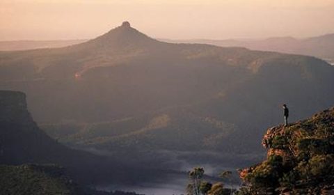
From the top of the mountain there are magnificent panoramic views of the rugged cliffs and gorges carved by the Clyde River and its tributaries. Dominating the view to the north-west are two elongated plateaux of Byangee Walls and The Castle. On a good day, coastline stretching from Point Perpendicular in the north to Mount Dromedary in the south can be seen, making the walk a most rewarding experience. The plateau has been dissected by streams to produce the grand mountain scenery of the Budawang Range. From the summit the different layers of sandstone can be traced in the surrounding cliffs. The vegetation on the summit includes the Pigeon House Ash which is found only in the Budawang area.
How to Get There: There are two roads that lead off the Princes Highway to the Pigeon House Mountain walking track. At Milton, turn into Croobyar Road or approximately 3kms south of Burrill Lake into the Wheelbarrow Road. Travel to the car park (road conditions pending) and picnic area at the start of the track (approx. 27kms).
Pigeon HouseThe walk to the top of Pigeon House Mountain and return takes about 4 hours. This walk can be divided into four stages:
Stage 1: A steep climb of 800m from the car park to the first cliff line and the National Park boundary. The track follows a steep spur through a forest of Black Ash with an open understorey. The rock types of this first section are metamorphosed Ordovician sediments that are about 490 million years old (give or take a year). The first sandstone cliff line is early Permian, which is about 250 million years old.
Stage 2: A flat walk of 1km from the top of the first cliff line to where the sandy track starts to climb again. Many wildflowers can be seen in spring and summer. Common plants are the Wattle and the Hairpin Banksia and many heaths.
Stage 3: A steep climb of 500m takes us to the famous ladders. Initially, the sandstone soils support heath and sedge but as the track climbs, the soil gets deeper and clayier allowing taller, denser vegetation to grow. Towards the top of this stage a wet forest grows where the Pigeon House cliff line provides shelter from the sun. Lyrebirds may be seen or heard here.
Stage 4: The summit of Pigeon House Mountain is reached by climbing a series of steel ladders attached to the cliff face. This peak is the southern most remnant of a once extensive sandstone plateau stretching north towards the Shoalhaven River.
Region X provide hosted Day Walks of Pigeon House Mountain Morton National Park including pickups in the Ulladulla Region and transportation